

Preview
Identifier
Winner, First Place
Creation Date
Spring 2020
Department
Technology
Narrative
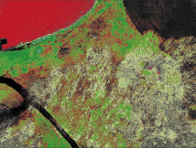
This image was taken by a MapIR spectral imaging camera attached to an autonomous UAV 180 feet above a 230-acre farm plot in Mount Sterling, IL. The UAV successfully took off, mapped the acreage, and landed autonomously allowing the surveyor to download the images after the fight for calibration. A color LUT has been applied to the image showing areas of healthy vegetation in green, moderate vegetation in yellow, and low to no vegetation in red and black. Each image details the amount of sunlight absorbed by the surrounding field recording light levels and NIR information before the image is calibrated. This type of photography can determine whether a field is suffering from a lack of sunlight, water, or nitrogen and can also determine insect or fungi damage. This program was launched as an independent study in the summer of 2019 but was later unable to obtain permissions from the Research and Sponsorship's department to further its research. If successful, this program could help diminish over-spraying of pesticides and nitrogen allowing the surrounding environment and ground water to become less polluted and giving farmers hours instead of weeks for faster turnarounds and better overall yields.