

Preview
Identifier
Winner, First Place
Creation Date
Spring 2023
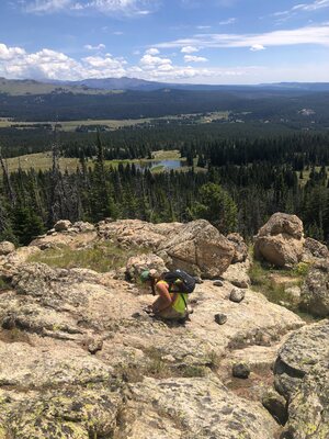
Description
My geology research required me to spend several weeks in the Bighorn Mountains of Wyoming to make a geologic map of the Spanish Point quadrangle. This image fully encompasses the science and beauty of geologic mapping. In the picture, I’m using a Brunton to measure the direction of the fabric in the rock at over 10,000 feet of elevation. In the background, one can see boulders moved by glaciers, mountain peaks, open fields, lakes, and the single dirt road that provided our access to the area. From this elevation, everything is below you except the sky.